| Home > All By Location regional map > Emsworth > Brighton Rd over Spruce Run | |||
|
|
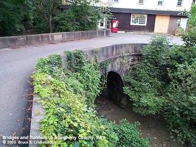
View north (upstream) More detail photos OFFICIAL NAME: OTHER DESIGNATION: Brighton Rd over Spruce Run emsw578-15 LOCATION: Ben Avon USGS 7.5" Topo Quad - UTM Coordinates: Emsworth - Zone 17; 0578 4483 CARRIES: Brighton Rd BETWEEN: -- at Spruce Run Rd -- Dickson Av CROSSES: -- Spruce Run TYPE OF CONSTRUCTION / DESIGN: stone arch locally-quarried sandstone outer spandrel wall: rock-faced coursed ashlar upper walls and parapets: dressed coursed ashlar arch ring: dressed voussoirs in semi-circular arch LENGTH OF MAIN SPAN: 17 ft TOTAL LENGTH (including longest elevated ramp): ft HEIGHT OF DECK: YEAR ERECTED / ENGINEER: 1896, Allegheny County Charles Davis, engineer ADDITIONAL INFO: During years surrounding 1900, Allegheny County, under the direction of County Engineer Charles Davis, was busy throughout the county building stone arch bridges of a simple and similar design. The parapet walls of this bridge are more rectangular than others designed by Davis. Owing to the path Brighton Rd takes in crossing the deep and narrow ravine of Spruce Run, combined with the intersection with Spruce Run Rd, the abutments and parapets of this structure are so curved as to form a near-180 degree turn. A carved stone builder's plaque is mounted on the inside center of the upstream parapet:
Allegheny County assigns its bridges with an ID number counting from a stream's outflow, sequentially upstream. A number one is painted on the carved stone builder plaque indicating this as the first bridge upstream from the point where Spruce Run flows into the Ohio River (Spruce Run Number 1). The are two other bridges downstream -- neither owned by the County (Spruce Run Rd and the railroad crossing Spruce Run). Brighton Rd was bypassed with the opening of Ohio River Boulevard in 1931. The boulevard crosses high above the Spruce Run Ravine on a open-spandrel concrete arch bridge. FIELD CHECKED: 11-April-2003 INFO SOURCES: Submit info or inquiry - share some facts or ask a question. Introduction -- Nearby Structures Page created: Last modified: 05-Nov-2003 |
View Larger Map View Larger Map 
| |
| copyright: © Bruce S. Cridlebaugh 1999-2008 All Rights Reserved | |||