| Home > All By Location regional map > Emsworth > Ohio River Boulevard over Lowrie's Run | |||
|
|
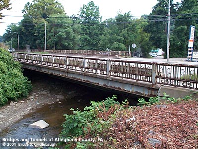
View southeast (downstream) More detail photos OFFICIAL NAME: Bridge Number 2, Lowrie's Run OTHER DESIGNATION: Ohio River Boulevard over Lowrie's Run LOCATION: Emsworth USGS 7.5" Topo Quad - UTM Coordinates: Emsworth - Zone 17; 0576 4484 CARRIES: Ohio River Boulevard [PA65] BETWEEN: -- Camp Horne Rd -- Hilands Av CROSSES: -- Lowrie's Run TYPE OF CONSTRUCTION / DESIGN: Pony steel girder on ashlar stone abutments LENGTH OF MAIN SPAN: 80 ft TOTAL LENGTH (including longest elevated ramp): 80 ft HEIGHT OF DECK: YEAR ERECTED / ENGINEER: 1930, Allegheny County Replaced 1911-12, PennDOT ADDITIONAL INFO: Metal builder's plaques are mounted on the railings on each side:
from the PennDOT Historic Bridges Survey: "The bridge carries a 4 lane highway with sidewalks over a stream. The highway, Ohio River Boulevard, was built in the late 1920s and early 1930s to connect Pittsburgh and its suburbs along that river. Now dominated by late 20th century commercial strip development, including an auto repair shop at the southwest quadrant and a converted gas station at the northeast quadrant, the road does not have historic district potential. FIELD CHECKED: 14-Aug-2004 INFO SOURCES: field check, PennDOT Historic Bridges Survey Submit info or inquiry - share some facts or ask a question. Introduction -- Nearby Structures Page created: Last modified: 28-Sep-2004 |
View Larger Map View Larger Map 
| |
| copyright: © Bruce S. Cridlebaugh 1999-2008 All Rights Reserved | |||