|
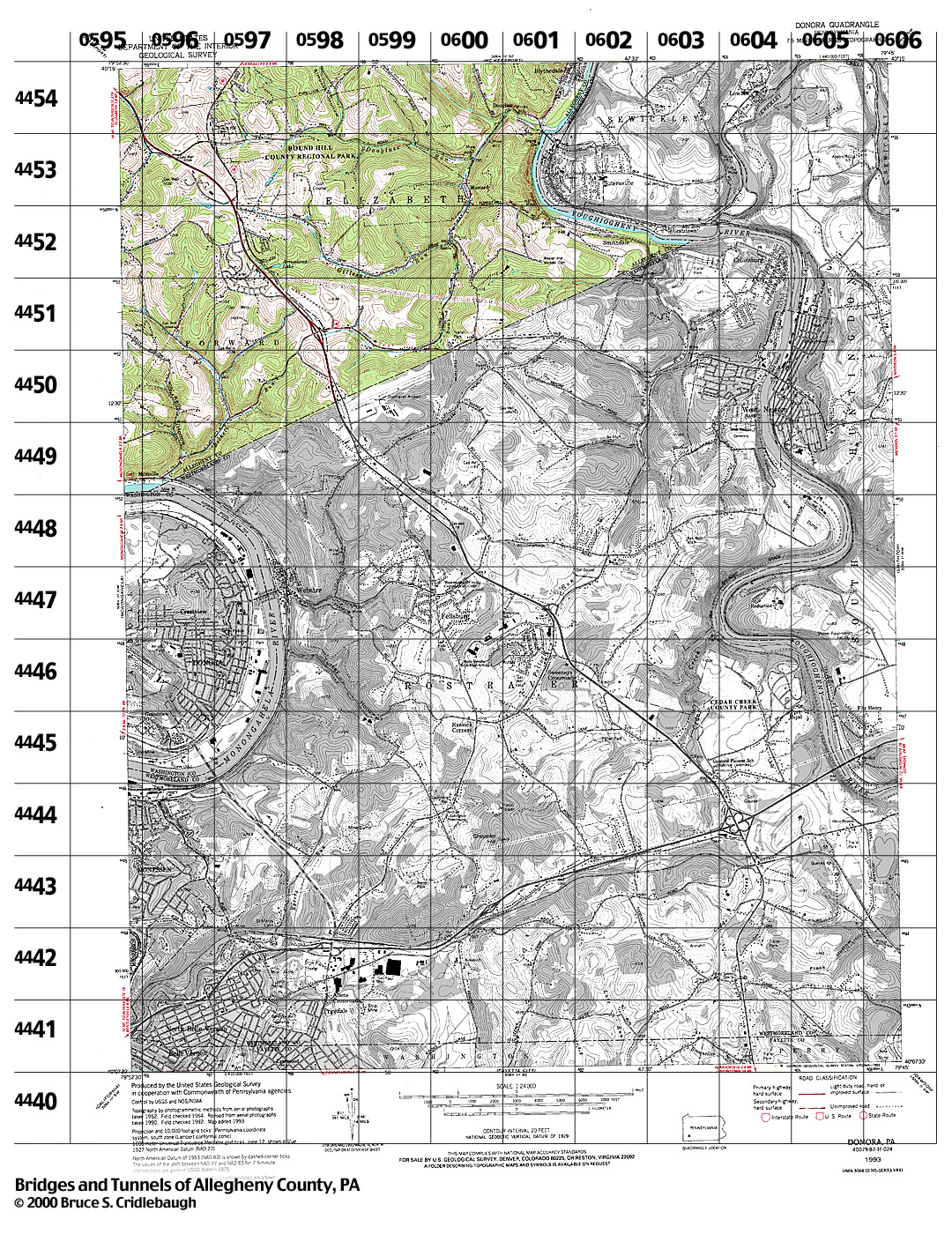
Structures Listed by Location
DONORA, PA - USGS 7.5" USGS 7.5" Topo Quad - UTM grid location in BOLD
view map - initial listings completed 27-Feb-2000
* indicates unconfirmed crossing
79° 52' 30" W --- 79° 45' 00" W;
40° 15' 00" N --- 40° 07' 30" N
Also try the Tours.
0595 4455
grid location also on Glassport, McKeesport and Monongahela topo quads
- Hayden Blvd [PA51] over tributary of Fallen Timber Run (Elizabeth Twp - Forward)
0587 4454
grid location also on Monongahela topo quad
- Sunnyside Rd ? over tributary of Fallen Timber Run, south of Hutchinson Rd (Forward)
0587 4453
grid location also on Monongahela topo quad
- Hillcrest St over tributary of Fallen Timber Run, at Guffey Rd (Forward)
0587 4452
grid location also on Monongahela topo quad
- none listed
0587 4451
grid location also on Monongahela topo quad
- none listed
0587 4450
grid location also on Monongahela topo quad
- none listed
0596 4455
grid location also on McKeesport topo quad
- none listed
0596 4454
- Hayden Blvd [PA51] over tributary of Fallen Timber Run, at Hutchinson Rd (Elizabeth Twp)
- Hutchinson Rd over tributary of Fallen Timber Run (Elizabeth Twp - Forward)
- Sunnyside Rd ? over tributary of Fallen Timber Run (Forward)
0596 4453
- none listed
0596 4452
- Kelley Hollow Rd over tributary of Beckets Run, north of Oak Dr (Forward)
- Kelley Hollow Rd over tributary of Beckets Run, at Oak Dr (Forward)
- PA136 over Beckets Run, east of Kelley Hollow Rd (Forward)
- Kelley Hollow Rd over Beckets Run (Forward)
- PA136 over Beckets Run, at Kelley Hollow Rd (Forward)
- PA906 over Beckets Run (Forward)
- PLE RR over Beckets Run (Forward)
0597 4455
- none listed
0597 4454
- Round Hill Rd Park entrance over tributary of Douglass Run (Elizabeth Twp)
- Round Hill Rd over tributary of Douglass Run (Elizabeth Twp)
0597 4453
- none listed
0597 4452
- Tunnel Hollow Rd over tributary of Beckets Run (Forward)
0597 4451
- Hillcrest St [Tunnel Hollow Rd] over tributary of Beckets Run, third crossing north of PA136 (Forward)
- Hillcrest St [Tunnel Hollow Rd] over tributary of Beckets Run, second crossing north of PA136 (Forward)
- Hillcrest St [Tunnel Hollow Rd] over tributary of Beckets Run, first crossing north of PA136 (Forward)
- PA136 over Beckets Run, at Hillcrest St [Tunnel Hollow Rd] (Forward)
0597 4450
- PA136 over Beckets Run, west of Hillcrest St [Tunnel Hollow Rd] (Forward)
0598 4455
- Round Hill Rd over tributary of Douglass Run, at Simpson Hollow Rd (Elizabeth Twp)
- Round Hill Rd over tributary of Douglass Run, west of Simpson Hollow Rd (Elizabeth Twp)
0598 4454
- Road to maintenance shed over tributary of Douglass Run (Elizabeth Twp)
0598 4453
- Pine View Dr over Gillespie Run, at Skyline Dr (Elizabeth Twp)
- Pine View Drive Gillespie Run, east of Skyline Dr (Elizabeth Twp)
0598 4452
- West Newton Rd [PA136] over PA51, interchange (Elizabeth Twp)
0598 4451
- none listed
0599 4455
grid location also on McKeesport topo quad
- none listed
0599 4454
- Road off Round Hill Rd over Douglass Run, east of Simpson Hollow Rd (Elizabeth Twp)
0599 4453
- Pine View Dr over tributary of Gillespie Run (Elizabeth Twp)
0599 4452
- West Newton Rd [PA136] over tributary of Gillespie Run, west of Long Hollow Rd (Elizabeth Twp)
- Long Hollow Rd over tributary of Gillespie Run (Elizabeth Twp)
0599 4451
- none listed
0599 4450
- none listed
0600 4455
grid location also on Glassport topo quad
- Douglass Run Rd over tributary of Douglass Run (Elizabeth Twp)
- Old RR grade over tributary of Douglass Run, south of Nichols Hill Rd (Elizabeth Twp)
0600 4454
- Old RR grade over Douglass Run, at Long Hollow Rd (Elizabeth Twp)
- Douglass Run Rd over Douglass Run, at Long Hollow Rd (Elizabeth Twp)
- Scotthill Rd over tributary of Douglass Run, west of Berdar Rd (Elizabeth Twp)
- Scotthill Rd over tributary of Douglass Run, at Berdar Rd (Elizabeth Twp)
- Berdar Rd over tributary of Douglass Run (Elizabeth Twp)
0600 4453
- Long Hollow Rd over tributary of Douglass Run, first crossing south of Forest Hill Rd (Elizabeth Twp)
- Long Hollow Rd over tributary of Douglass Run, second crossing south of Forest Hill Rd (Elizabeth Twp)
- Long Hollow Rd over tributary of Douglass Run, south of Skillet Hill Rd (Elizabeth Twp)
- Long Hollow Rd over tributary of Douglass Run, at Pine View Dr (Elizabeth Twp)
- Long Hollow Rd over tributary of Douglass Run, south of Pine View Dr (Elizabeth Twp)
0600 4452
- Long Hollow Rd over tributary of Douglass Run, second crossing north of West Newton Rd [PA136] (Elizabeth Twp)
- West Newton Rd [PA136] over tributary of Douglass Run, east of Long Hollow Rd (Elizabeth Twp)
0601 4455
grid location also on McKeesport topo quad
- Blythedale Dr over creek, at Shaler St (Elizabeth Twp)
- Yough Trail [PLE RR] over creek, at Parkvue St (Elizabeth Twp)
- Old RR grade over Douglass Run, south of Nichols Hill Rd (Elizabeth Twp)
- Douglass Run Rd ? over Douglass Run, south of Blythedale Dr (Elizabeth Twp)
- Yough Trail [PLE RR] over Douglass Run (Elizabeth Twp)
view page
- Sutersville Bridge over Youghiogheny River (Elizabeth Twp, Allegheny Co. - Sutersville, Westmoreland Co.)
view page
- Sutersville Bridge [c1900] over Youghiogheny River (Elizabeth Twp, Allegheny Co. - Sutersville, Westmoreland Co.)
0601 4454
- none listed
0601 4453
- Old RR grade over Smithdale Rd ? (Elizabeth Twp)
0601 4452
- none listed
0602 4453
- none listed
0602 4452
- none listed
0603 4453
- Yough Trail [PLE RR] over Pollock Run (Elizabeth Twp)
- Smithdale Rd over tributary of Pollock Run
Submit info or inquiry - share some facts or ask a question.
Page created:
Last modified:
11-Dec-2001
|
bridge, Pittsburgh, bridges, tunnel, tunnels, Pennsylvania, PA, Allegheny, Allegheny County, pittsburgh bridge, pittsburgh bridges, bridges pittsburgh, bridge pittsburgh, bridge, Pittsburgh, bridges, tunnel, tunnels, Pennsylvania, PA, Allegheny, Allegheny County, pittsburgh bridge, pittsburgh bridges, bridges pittsburgh, bridge pittsburgh, bridge, Pittsburgh, bridges, tunnel, tunnels, Pennsylvania, PA, Allegheny, Allegheny County, pittsburgh bridge, pittsburgh bridges, bridges pittsburgh, bridge pittsburgh, structure, truss, arch, beam, highway, road, railroad, engineering, civil engineering, trestle, viaduct, concrete, steel, stone, masonry, map, bridge, bridges, tunnel, tunnels, Pittsburgh, Pennsylvania, PA, Allegheny, Allegheny County, structure, truss, arch, beam, highway, road, railroad, engineering, civil engineering, trestle, viaduct, concrete, steel, stone, masonry, map, bridge, bridges, tunnel, tunnels, Pittsburgh, Monongahela River, Ohio River, Allegheny River, Pennsylvania, PA, Allegheny, Allegheny County, structure, truss, arch, beam, highway, road, railroad, engineering, civil engineering, trestle, viaduct, concrete, steel, stone, masonry, map, glossary, definitions, terms, terminology, glossary, definitions, terms, terminology, glossary, definitions, terms, terminology,bridge, Pittsburgh, bridges, tunnel, tunnels, Pennsylvania, PA, Allegheny, Allegheny County, pittsburgh bridge, pittsburgh bridges, bridges pittsburgh, bridge pittsburgh |