Search pghbridges.com
Search WWW


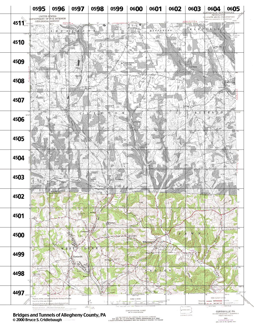
Structures Listed by Location
CURTISVILLE, PA - USGS 7.5" Topo Quad - UTM grid location in BOLD
view map - initial listings completed 06-Apr-1999

79° 52' 30" W --- 79° 45' 00" W;
40° 45' 00" N --- 40° 37' 30" N


Also try the Tours.


0595 4502
grid location also on Valencia topo quad

- Armstrong Rd over tributary of Bull Creek (West Deer)*


0595 4501
grid location also on Valencia topo quad

- none listed


0595 4500
grid location also on Valencia topo quad

- none listed


0595 4499
grid location also on Valencia topo quad

- none listed


0595 4498
grid location also on Valencia topo quad

- none listed


0595 4497
grid location also on Glenshaw, New Kensington West, and Valencia topo quads

- none listed


0596 4502

- Armstrong Rd over tributary of Bull Creek (West Deer)*


0596 4501

- Armstrong Rd over tributary of Bull Creek (West Deer)*


0596 4500

- none listed


0596 4499

- none listed


0596 4498

- Saxonburg Blvd over tributary of Little Deer Creek south of McKrell Rd (West Deer)


0596 4497
grid location also on New Kensington West topo quad

- none listed


0597 4502

- none listed


0597 4501

- none listed


0597 4500

- none listed


0597 4499

- Saxonburg Blvd over tributary of Little Deer Creek near McKrell Rd (West Deer)

- Saxonburg Blvd old alignment over tributary of Little Deer Creek near McKrell Rd (West Deer)


0597 4498

- none listed


0597 4497
grid location also on New Kensington West topo quad

- none listed


0598 4502

- Saxonburg Blvd over tributary of Bull Creek south of Henrey Rd (West Deer)*
- Dawson Rd over tributary of Bull Creek


0598 4501

- BLE RR crossings at Red Hot along Saxonburg Blvd (West Deer)*


0598 4500

view page - Bakerstown Rd [Millerstown and Culmerville Rd; Red Belt] over BLE RR (West Deer)


0598 4499

- Little Deer Creek Valley Rd over tributary of Little Deer Creek (West Deer)*


0598 4498

- BLE RR over Benjamin Rd (West Deer)
- Benjamin Rd over Little Deer Creek (West Deer)


0598 4497
grid location also on New Kensington West topo quad

- Little Deer Creek Valley Rd over tributary of Little Deer Creek at Superior Rd (West Deer)*


0599 4502

view page - BLE RR over Dawson Rd "Ghost Tunnel" [tunnel] (West Deer)
- BLE RR over tributary of Bull Creek (West Deer)*
- BLE RR over Bull Creek north of Dawson Rd (West Deer)*
- Dawson Rd over Bull Creek east of Saxonburg Blvd (West Deer)*


0599 4501

- none listed


0599 4500

- none listed


0599 4499

- none listed


0599 4498

- none listed


0599 4497
- none listed


0600 4502

- none listed


0600 4501

- Dawson Rd over Bull Creek at Hemphill Rd (Fawn)*
- Dawson Rd over Bull Creek east of Hemphill Rd (Fawn)*


0600 4500

- none listed


0600 4499

- none listed


0600 4498

- none listed


0600 4497
grid location also on New Kensington West topo quad

- none listed


0601 4502

- Lardintown Rd over Lardintown Run at Butler County line (Fawn)*


0601 4501

- none listed


0601 4500

- Lardintown Rd over Lardintown Run north of Millerstown and Freeport Rd (Fawn)*


0601 4499

- Dawson Rd over Bull Creek north of Millerstown (Fawn)*
- Millerstown and Freeport Rd over Bull Creek (Fawn)*
- Bull Creek Rd [Red Belt] over tributary of Bull Creek near Millerstown (Fawn)*
- Dellenbough Rd over tributary of Bull Creek near Millerstown (Fawn)*
- Bull Creek Rd [Red Belt] over tributary of Bull Creek east of Dellenbough Rd (Fawn)*


0601 4498

- Dellenbough Rd over tributary of Bull Creek (Frazer)*


0601 4497
grid location also on New Kensington West topo quad

- none listed


0602 4502

- none listed


0602 4501

- none listed


0602 4500

- Lardintown Rd over tributary of Lardintown Run at Millerstown and Freeport Rd (Fawn)*
- Lardintown Rd over Bull Creek south of Millerstown and Freeport Rd (Fawn)*
- Lardintown Rd over Lardintown Run south of Millerstown and Freeport Rd (Fawn)*
- Bull Creek Rd [Red Belt] over tributary of Bull Creek at Lardintown Rd (Fawn)*


0602 4499

- none listed


0602 4498

- none listed


0602 4497
grid location also on New Kensington West topo quad

- none listed


0603 4502

- none listed


0603 4501

- Millerstown and Freeport Rd over tributary of McDowell Run (Fawn)*


0603 4500

- none listed


0603 4499

- Bull Creek Rd [Red Belt] over Bull Creek east of McDowell Run Rd (Fawn)*
- Bull Creek Rd [Red Belt] over Bull Creek west of McDowell Run Rd (Fawn)*


0603 4498

- none listed


0603 4497
grid location also on New Kensington West topo quad

- none listed


0604 4502

- none listed


0604 4501

- Howes Run Rd over McDowell Run north of Millerstown and Freeport Rd (Fawn)*
- Millerstown and Freeport Rd over McDowell Run (Fawn)*
- Howes Run Rd over McDowell Run south of Millerstown and Freeport Rd (Fawn)*


0604 4500

- none listed


0604 4499

view page - Howes Run Rd over McDowell Run north of Bull Creek Rd, 1915 stone-veneer concrete arch (Fawn)


0604 4498

- Bull Creek Rd [Red Belt] over tributary of Bull Creek (Fawn)*
- Bull Creek Rd [Red Belt] over Bull Creek, north of Haas Ln (Fawn)
view page - Bull Creek Rd [Red Belt] AC #2 over Bull Creek, south of Haas Ln, 1922 stone-veneer concrete arch (Fawn)


0604 4497
grid location also on New Kensington West topo quad

- Bull Creek Rd [Red Belt] over tributary of Bull Creek (Fawn)*


0605 4502
grid location also on Curtisville topo quad

- Millerstown and Freeport Rd over tributary of McDowell Run east of McDowell Run Rd (Fawn)*


0605 4501
grid location also on Curtisville topo quad

- none listed


0605 4500
grid location also on Curtisville topo quad

- none listed


0605 4499
grid location also on Curtisville topo quad

- none listed


0605 4498
grid location also on Curtisville topo quad

- none listed


0605 4497
grid location also on Freeport, New Kensington East, and New Kensington West topo quads

- none listed


Submit info or inquiry - share some facts or ask a question.

Page created:
Last modified: 30-Jun-2004


sidebar bridge, Pittsburgh, bridges, tunnel, tunnels, Pennsylvania, PA, Allegheny, Allegheny County, pittsburgh bridge, pittsburgh bridges, bridges pittsburgh, bridge pittsburgh, bridge, Pittsburgh, bridges, tunnel, tunnels, Pennsylvania, PA, Allegheny, Allegheny County, pittsburgh bridge, pittsburgh bridges, bridges pittsburgh, bridge pittsburgh, bridge, Pittsburgh, bridges, tunnel, tunnels, Pennsylvania, PA, Allegheny, Allegheny County, pittsburgh bridge, pittsburgh bridges, bridges pittsburgh, bridge pittsburgh, structure, truss, arch, beam, highway, road, railroad, engineering, civil engineering, trestle, viaduct, concrete, steel, stone, masonry, map, bridge, bridges, tunnel, tunnels, Pittsburgh, Pennsylvania, PA, Allegheny, Allegheny County, structure, truss, arch, beam, highway, road, railroad, engineering, civil engineering, trestle, viaduct, concrete, steel, stone, masonry, map, bridge, bridges, tunnel, tunnels, Pittsburgh, Monongahela River, Ohio River, Allegheny River, Pennsylvania, PA, Allegheny, Allegheny County, structure, truss, arch, beam, highway, road, railroad, engineering, civil engineering, trestle, viaduct, concrete, steel, stone, masonry, map, glossary, definitions, terms, terminology, glossary, definitions, terms, terminology, glossary, definitions, terms, terminology,bridge, Pittsburgh, bridges, tunnel, tunnels, Pennsylvania, PA, Allegheny, Allegheny County, pittsburgh bridge, pittsburgh bridges, bridges pittsburgh, bridge pittsburgh