| Home > All By Location regional map > Bridgeville > Montour Trail [former Montour Railroad] over Library Rd | |||
|
|
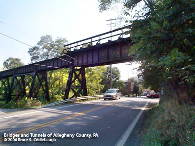
View east on Library Rd More detail photos OFFICIAL NAME: Library Viaduct OTHER DESIGNATION: Library Trestle Montour Trail [former Montour Railroad] over Library Rd LOCATION: Snowden Twp USGS 7.5" Topo Quad - UTM Coordinates: Bridgeville - Zone 17; 0582 4460 CARRIES: -- future Montour Trail (recreational rail-trail) -- former Montour Railroad BETWEEN: -- at trail mile 35.2 CROSSES (north to south): -- Port Authority "T" light rail -- Piney Fork -- Library Rd [PA88] TYPE OF CONSTRUCTION / DESIGN: plate girder on trussed bents 11 spans, including 3 trussed towers LENGTH OF MAIN SPAN: Library Rd span - 60 ft est Port Authority "T" span - 72 ft est TOTAL LENGTH (including longest elevated ramp): 506 ft; 1.60 grade descending west HEIGHT OF DECK: YEAR ERECTED / ENGINEER: 1918, Montour Railroad ADDITIONAL INFO: With a mainline of some 45 miles, the Montour Railroad once served the coal mines and industries of southern Allegheny County and northern Washington County. Arcing southward and westward from Montour Junction near Coraopolis on the Ohio River (interchange with the Pittsburgh & Lake Erie RR), the mainline dipped into Washington County. In Peters Township, the Library Branch left the mainline and both lines curved back into Allegheny County. While the mainline continued northward into West Mifflin and an interchange with the industrial Union Railroad, the Montour's Library Branch continued more westerly to Snowden. In 1918, the Montour Railroad built the two-mile segment eastward from Library toward the site of Pittsburgh Coal Company's Montour Number 10 mine. At branch mile post 1.8, the Library Branch crossed the wide valley of Piney Fork, a tributary of Peters Creek, which itself flows into the Monongahela River at Clairton. The 506 foot long trussed viaduct also carried the railroad over Library Rd and the two tracks of Pittsburgh Railways interurban trolley connecting Pittsburgh and Charleroi. Just west of the viaduct, the yard serving Montour Number 10 mine stretched between Pleasant St and Stewart Rd. In 1929, the Library Branch was extended 3 miles: 2.33 miles of new construction and 0.82 miles of trackage rights on the PRR Peters Creek Branch. The interchange was called Pennmont [Pennsylvania-Montour]. From Pennmont, the Montour extension also created an interchange with the Baltimore & Ohio W&P subdivision. The Library Viaduct crosses above the former Pittsburgh Railways interurban which linked Pittsburgh and Charleroi from just after 1900 until June 1953. The Pittsburgh Railways properties were acquired by the Port Authority of Allegheny County in 1964. For the most part, all trolley lines and rights-of-way were eliminated throughout Allegheny County. With construction beginning in 1981, the "T" light rail system began operation into Pittsburgh's South Hills suburbs in 1987 after reconstruction of the previous trolley right-of-way through Beechview. The Overbrook line, originally built by Pittsburgh Railways along Saw Mill Run near Pittsburgh, runs south to its terminus at Library. It was closed in 1993 due to safety concerns related to several trestles and a roadbed either single-tracked or double-tracked but too-closely-spaced for light rail. Traffic to Library was rerouted through Beechview to Washington Junction. The Stage II LRT project rebuilt the Overbrook and Library routes as modern double-tracked lines, reopening in 2004. The Montour Trail Council (MTC) is a non-profit all-volunteer group which builds, operates, and maintains the trail. Beginning in 1989, the Montour Trail has been rebuilding the former railroad right-of-way. It is "paved with a smooth surface of crushed limestone, which makes it ideal for all forms of non-motorized use: bicycling, walking, running, cross-country skiing, and nature appreciation. In certain sections, horseback riding is also permitted, but not on the improved trail surface. A portion of the trail within Peters Township is called The Arrowhead Trail. It is owned and maintained by the Township." The trail includes several notable bridges and tunnels. The Montour Trail website states: "Currently (2009), original railroad rails are mounted on the (Library) Trestle deck. This project will involve removing the existing rails and ties from the Trestle, making some structural improvements to the bridge, then installing a new deck/fencing. There are short sections of trail on either side of the bridge that will also be built." Estimated rehabilition completion date, 2011. ===== from wikipedia: "The Montour Railroad" "The Montour Railroad Company was chartered in 1877 as a wholly owed subsidiary of the Imperial Coal Company. The first segment constructed extended from the Pittsburgh and Lake Erie Railroad line at Montour Junction, near Coraopolis, Pennsylvania to the Imperial Coal Company mines at Imperial, Pennsylvania. In 1901, the Pittsburgh Coal Company assumed control of the railroad. A major expansion was undertaken in 1912 to reach new coal mines and factories. By 1917, the town of West Mifflin, Pennsylvania on the Monongahela River was reached. The Montour Railroad became an important feeder line and eventually all five major truck carriers in the southwestern Pennsylvania market were linked to the Montour Railroad. In 1946 the Pittsburgh Coal Company sold the Montour Railroad to the Pennsylvania Railroad and the Pittsburgh and Lake Erie Railroad (a subsidiary of the New York Central Railroad), who operated it jointly. The P&LE acquired sole control of the Montour Railroad in 1975. FIELD CHECKED: 28-Aug-2004 INFO SOURCES: field check; Gene P. Schaeffer, montourrr.com and "The Montour Railroad"; Montour Trail website; Port Authority of Allegheny County; Roger DuPuis, "PRC Online"; "Corporate History of the PRR," Valuation Reports Vol. 22 pp 278-301, 358-365, Interstate Commerce Commission, January 1929 (transcribed by Robert Netzlof) Submit info or inquiry - share some facts or ask a question. Introduction -- Nearby Structures Page created: 30-Mar-2009 Last modified: 03-Apr-2009 |
View Larger Map 
| |
| copyright: © Bruce S. Cridlebaugh 1999-2008 All Rights Reserved | |||