| Home > All By Location regional map > Bridgeville > Baldwin St over McLaughlin Run | ||||
|
|
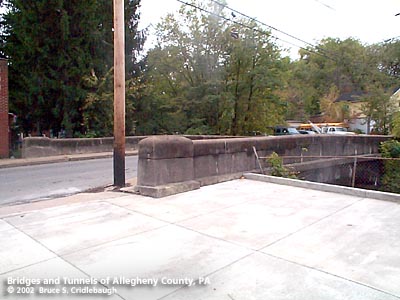
View southwest (upstream left)
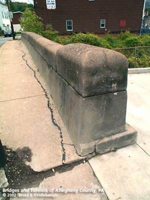
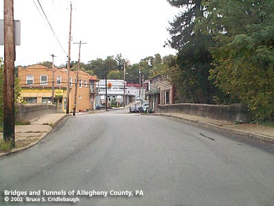
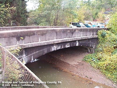
OFFICIAL NAME: OTHER DESIGNATION: Baldwin St over McLaughlin Run brid575-13 LOCATION: Bridgeville USGS 7.5" Topo Quad - UTM Coordinates: Bridgeville - Zone 17; 0575 4467 CARRIES: Baldwin St BETWEEN: -- McLaughlin Run Rd [Orange Belt] -- Margaret St CROSSES: -- McLaughlin Run TYPE OF CONSTRUCTION / DESIGN: Closed spandrel concrete arch; Parapet walls: concrete formed modules LENGTH OF MAIN SPAN: 35 ft TOTAL LENGTH (including longest elevated ramp): HEIGHT OF DECK: YEAR ERECTED / ENGINEER: 1935, Allegheny County ? ADDITIONAL INFO: The characteristics of this bridge seem to match many others built between c1910 and c1936 by the Allegheny County Public Works Department. During years surrounding 1900, Allegheny County, under the direction of County Engineer Charles Davis, was busy throughout the region building stone arch bridges of a simple and similar design. Typically, they featured parapets with rounded top and slightly enlarged parapet endcaps. Beginning about 1910 -- after Chalfant assumed the position of County Engineer -- new county bridges of this size were being constructed solely in concrete using a design which mimicked the earlier stone arches. On a few of the concrete structures, a builder's plate identifies the bridge as having been constructed by Allegheny County and includes the stream name and date. Several bridges of this design are found throughout Allegheny County, but usually without the builder's plate to confirm the date or the authority in charge of construction. The similar of design and construction seems to imply that they were all built by Allegheny County, and other sources state construction dates to about 1936. This arched design was phased out and replaced by simpler beam bridges. The bridge seems reasonably intact. Examination of the other bridges of this design typically have parapet walls which are severely crumbling. The parapets appear to have been constructed by stacking a series of formed concrete modules. The modules were shaped to mimic the rounded caps found on County bridges designed by Davis. Each block seems to have weathered differently and the seams between them allowed further decay. The Old Butler Plank Rd bridge over Gourhead Run is another well preserved example. The closed spandrel walls and outer faces of the parapets have recessed panels which further echo the designs from the County's earlier stone arch bridges. FIELD CHECKED: 13-Oct-2002 INFO SOURCES: field check Submit info or inquiry - share some facts or ask a question. Introduction -- Nearby Structures Page created: Last modified: 07-May-2003 |
View Larger Map View Larger Map 
| ||
| copyright: © Bruce S. Cridlebaugh 1999-2008 All Rights Reserved | ||||