| Home > All By Location regional map > Braddock > Former Pennsylvania Railroad [PRR, NSRR] over Turtle Creek at Bessemer | |||
|
|
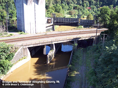
Former PRR [NSRR] crosses Turtle Creek with floodgates beyond downstream More detail photos OFFICIAL NAME: OTHER DESIGNATION: Former Pennsylvania Railroad [PRR, NSRR] over Turtle Creek at Bessemer LOCATION: East Pittsburgh - North Versailles USGS 7.5" Topo Quad - UTM Coordinates: Braddock - Zone 17; 0598 4471 CARRIES: -- 2 tracks, Norfolk Southern railroad [NSRR]; former Pennsylvania Railroad [PRR] -- once carried 5 tracks BETWEEN: -- CROSSES (west to east): -- old Braddock Ave (closed, with street railway tracks) -- Turtle Creek TYPE OF CONSTRUCTION / DESIGN: stone arch with concrete extensions 3 spans (2 spans over Turtle Creek, 1 span over street) LENGTH OF MAIN SPAN: TOTAL LENGTH (including longest elevated ramp): 145 ft est HEIGHT OF DECK: 30 ft est above Turtle Creek YEAR ERECTED / ENGINEER: Pennsylvania Railroad; Norfolk Southern Railroad, current owner ADDITIONAL INFO: Adjacent downstream to the railroad bridge is a vertical lift floodgate (no longer operational). The St. Patrick's Day Flood of 1936 brought backfow from the Monongahela River into the Turtle Creek Valley. The creek flooded again in May 1946, covering Brinton Rd and Braddock Av. The floodgate was constructed in 1950 to isolate the creek valley from the river. The Turtle Creek Flood Control Project built by the U.S. Army Corps of Engineers, 1963-67, further controlled the creek. Sloping concrete walls contain the stream from Wilmerding downstream past East Pittsburgh. Part of the Mon-Fayette Expressway plan is for Allegheny County Public Works to remove the floodgates. FIELD CHECKED: 21-Aug-2004 INFO SOURCES: field check Submit info or inquiry - share some facts or ask a question. Introduction -- Nearby Structures Page created: 26-Feb-2009 Last modified: 26-Feb-2009 |
View Larger Map 
| |
| copyright: © Bruce S. Cridlebaugh 1999-2008 All Rights Reserved | |||