| ||||
| Home > All By Location regional map > Ambridge > Pittsburgh-Rochester Rd [old alignment] over Big Sewickley Creek | ||||
|
|
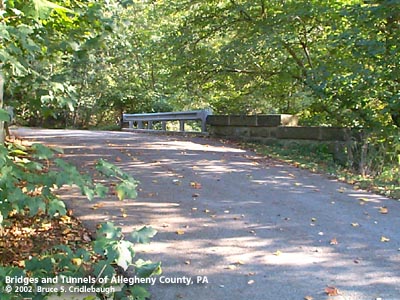
View east (downstream right)
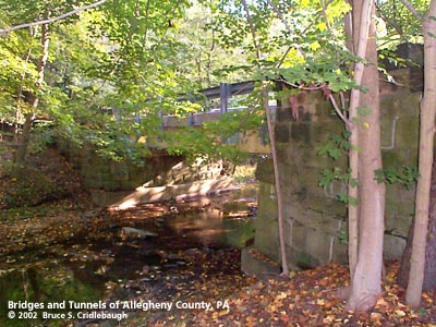
OFFICIAL NAME: Allegheny County Bridge Number 5 Big Sewickley Creek [SB05] OTHER DESIGNATION: Pittsburgh-Rochester Rd [old alignment] over Big Sewickley Creek ambr572-2 LOCATION: Marshall USGS 7.5" Topo Quad - UTM Coordinates: Ambridge - Zone 17; 0572-4496 CARRIES: Pittsburgh-Rochester Rd old alignment adopted as private drive at 2705 Warrendale and Bayne Rd BETWEEN: -- Warrendale and Bayne Rd [Red Belt] -- private residence CROSSES: -- Big Sewickley Creek TYPE OF CONSTRUCTION / DESIGN: riveted steel plate girder abutments: locally-quarried sandstone, rock-faced coursed ashlar LENGTH OF MAIN SPAN: ft TOTAL LENGTH (including longest elevated ramp): ft HEIGHT OF DECK: YEAR ERECTED / ENGINEER: c1900, Allegheny County Charles Davis, engineer ADDITIONAL INFO: During years surrounding 1900, Allegheny County, under the direction of County Engineer Charles Davis, was busy throughout the county building stone arch bridges of a simple and similar design. In some places, however, the crossings were built as riveted plate girder spans. The abutments of these girder bridges exhibit similar stonework to the County's stone bridges -- helping to identify their place in time and origin. A glance at the construction dates indicates that many of the earlier bridge were of the girder type. One possible explanation for the choice of an arch span versus a girder span may be found in the shape of the land onsite. Where the stream has high banks and can therefore hold rising waters of a flash flood, the bridges are usually stone arches. In places with relatively wide, flat channels, the spans are most often girders. In each instance, the goal was to maintain the level of the road surface as the road approaches and then enters the bridge -- while allowing maximum potential stream flow; sites which made this impractical have since been regraded or replaced. Allegheny County assigns its bridges with an ID number counting from a stream's outflow, sequentially upstream. Because of its age, this bridge defies the system. Tracing Big Sewickley Creek upstream from the Ohio River near Ambridge, one finds many bridges have been added as the road meanders through several realignments. A cast number plate identifies this bridge as "6" (Big Sewickley Creek Number 6). The next bridge upstream a few hundred feet is marked as "5" -- out of sequence. This is probably due the order of construction: the original courses of Big Sewickley Creek Rd and the old Pittsburgh-Rochester Rd were on the eastern side of the creek. Rochester Rd extended from near Pittsburgh (Millvale area) to Rochester in Butler County; it was apparently a popular alternative to the Beaver Rd along the Ohio River. The c1900 USGS topo maps of the area show the old placement of the roads. Big Sewickley Creek Rd was relocated westward in 1929 as part of the upgrading for the Belt Route System; the section Pittsburgh-Rochester Rd crossing into Beaver County fell into disuse; and the pair of near-twin girder spans over Big Sewickley Creek were given over to be used as driveways to private residences. view page - Big Sewickley Creek Rd [old alignment] over Big Sewickley Creek [SB06]. FIELD CHECKED: 7-Oct-2002 INFO SOURCES: field check, cited maps Submit info or inquiry - share some facts or ask a question. Introduction -- Nearby Structures Page created: 01-Apr-2003 Last modified: 01-Apr-2003 |
View Larger Map 
| ||
| copyright: © Bruce S. Cridlebaugh 1999-2008 All Rights Reserved | ||||