| Home > Articles > Fieldnotes: West Carson St Tunnel Portal | |||
|
|
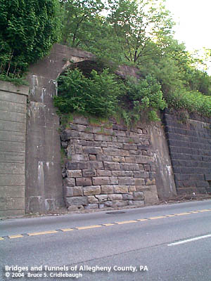
Field Notes: West Carson St Tunnel Portal In response to many inquiries: > > What's that blocked up tunnel portal on West Carson Street between the West End and the Corliss Tunnel? < <
I don't think it was a full tunnel through the hill. There's nowhere for it to come through on the other side. And a tunnel of this size certainly would have been noted in other historical sources. === First, some railroad history since the portal would not be needed otherwise -- then some thoughts about things that would tie together either side of the railroad. The railroad was first placed here by the Pittsburgh & Steubenville Railroad in 1858. The P&S carved a shelf out of the hillside on its way to a station in Birmingham on Pittsburgh's South Side. The line was connected to the PRR's Union Station downtown in 1863 via the Panhandle Bridge. Heading westward, the P&S curved away from the river near Sheraden at the present site of the Corliss Tunnel. The P&S was acquired in 1868 as part of the Pittsburgh, Cincinnati, Chicago & St. Louis Railroad -- a forerunner of the Pennsylvania Railroad. To alleviate freight traffic through downtown Pittsburgh, the Ohio Connecting Railway Bridge was built across the Ohio River at Brunot Island in 1890. The PCCStL and the OCRwy came together just to the west of the "portal" location; a 1917 map shows as many as eight tracks here and the area was controlled by DU tower interlocking, aka Elliott. So one possible reason for the portal is access to DU tower or the switching facilities there. An 1897 photo taken on West Carson St shows an older-style DU tower building with a wooden stairway leading from the street to the railroad. In the photo the hillside does not have retaining walls in this area: they were built later as West Carson St was widened (1911). Some of the stone walls are, however, visible in the photo's distance toward downtown. But the detail is difficult to discern. The portal is not in the 1897 photo, but does appear in a 1911 photo...with a newer-style DU tower building atop. Wagon access to track level would have been easier from the west near Danley and Rudd streets -- the present location of the Corliss Tunnel. === In trying to determine a date for the portal, there are not many clues along West Carson Street, except for the patchwork retaining wall which supports the railroad above. It is obvious that the wall was built in sections, at different times. There are no date stones. The succession of railroads built here began as a relatively narrow right-of-way; the 1897 photo shows that retaining walls were not built everywhere. But as the shelf was widened, tracks were added, and the roadway below was widened, walls were constructed. Farther west where the OCRwy bridge abutments were built adjacent to West Carson Street, stonecutters marks are evident. It was apparently common practice circa 1890 for workers to "sign" the stones they had finished. At several other locations around Pittsburgh, these marks are visible on structures which were built in the same time period. Yet, there are no obvious marks on the stones near the portal. To the right of the portal, the stone wall is finished cleanly with no evidence of it having been cut to insert the portal. To the left is a concrete retaining wall which is similar to those built by road construction authorities: in 1931, Allegheny County Public Works built the West End Circle approach to the West End Bridge. The portal itself is made of concrete with vertical walls and an arched ceiling. The front face of the portal is battered (tilted back at the top) to approximate the battered face of the adjacent stone wall. (The stone wall was built this way to allow gravity to help retain the weight of the fill.) That concrete was used suggests that the portal may have been built around 1905-1915 at the earliest. === Then, what could be on the other side of the tracks that would cause a portal to be built below the railroad? At first viewing, there is nothing but a cliff face rising to an elevation of 1000 feet above sea level: 290 feet above river level; about 260 feet above West Carson Street. If not for Saw Mill Run having carved out its valley in the West End, this hilltop would be an extension of Mount Washington. According to an 1898 History of Allegheny County published by Werner, this part of the Saw Mill Run Valley and the hillside to its north were part of a 150 acre farm titled to a man named West Elliott by the state of Virginia. The farm included a stone gristmill said to be in the same location as that built by British soldiers, the namesake saw mill and saltworks. West Elliott's heirs sold 96 acres in the valley and hillside to Issac Warden and John Alexander who laid out the town of Temperanceville in 1839. It was incorporated as a borough in 1859 and annexed into Pittsburgh in 1872. Meanwhile, higher up on the hilltop, the Lorenz family farm was being divided by real estate speculators including C.H. Love who platted the lots south of Lorenz Avenue before 1872. Love Avenue became Lakewood Street when the city removed duplicate names throughout its newly annexed neighborhoods. Mr. Love's optimism for selling the land to home builder's was joined by others including someone named Sawyer -- possibly N.P. Sawyer, who founded the Republic newspaper and also laid out the nearby town of Aschenaz (now Sheraden) in 1872. On the hilltop the boom slowed by 1910, and a large part of the western section became St. Martin's Roman Catholic Cemetery (which featured many German gravemarkers inscribed in German.) A series of property plat maps was published by G.M. Hopkins and various plates show the Elliott neighborhood of Pittsburgh through the years. Within the Sawyer Plan, the hillside between Rue Grand Vue and West Carson St includes plots owned by John Snyder and F. Snyder. Interestingly, both the 1872 and 1886 map editions show a strip of land extended directly over the cliff, connecting Rue Grand Vue and the Ohio River. The 1901 map (admittedly unreliable as it is an index of a larger volume) indicates a street right-of-way there. The 1917 edition shows a few more issues resolved: William Mitchell had transfered his land to the St. Martin's Cemetery and the Snyder land was now under the ownership of Mary L. Praeger. The Praeger land remains vacant today. So is it possible that John Snyder would not release rights to the railroad to cross his land? Was there some kind of easement created? Perhaps a mine -- although the Hopkins maps typically show mine inclines, entrances and such...and they are absent on all editions there. 1872 map -- 1886 map -- 1901 map -- 1917 map -- 2003 map === This leads to the third theory: access to an old road right-of-way. Attempts to place a regular street grid on Pittsburgh's hillsides always look good on paper, but rarely resemble what is ultimately built. Between Temperanceville and the Elliott hilltop, there is an area in which the topography refused to be conquered by straight lines. What looks like the broad avenue of Boundary Street in 1872, became Attica Street. Centre Street, a paper street which only appears on maps, is shown to climb the hill directly from Elliott Street to Boundary Street -- where it intersects with the hilltop grid at Virginia (now Valonia) Street. From this intersection, Centre Street turns to skirt the crest of the hill, maintaining a level course around to the cliff facing the Ohio River. Only this curving part of Centre St exists in fact. And it is now Corfu Street. A few 1890-1910 houses were built on the ledge. At the time there probably wasn't much to see -- with all of industry's heavy smoke hanging in the air -- but today these houses have some of the best seats in town for Pittsburgh's fireworks. Further examination of the earlier -- albeit suspiciously optimistic -- plat maps, show Centre Street as continuing past its present dead end and extending along the cliff face. There are no indications on these maps that the street would have descended to West Carson Street. But the proximity of the street, the hillside and the portal on West Carson all seem to be situated in such a way as to make it a possibility that the portal was built to allow Centre Street, now Corfu Street, to pass below the railroad and meet West Carson. === So, if you've read this far...I have resisted updating this page because of the fun of the mystery. But I'm adding the 1897 photo with the older DU tower building, stairs from the street, and no portal -- and the 1911 street-widening photo of the newer DU Tower that shows the portal being its base. Tim says: "They moved the stairs there when they built the wall, then blocked the entrance when they tore down the tower." 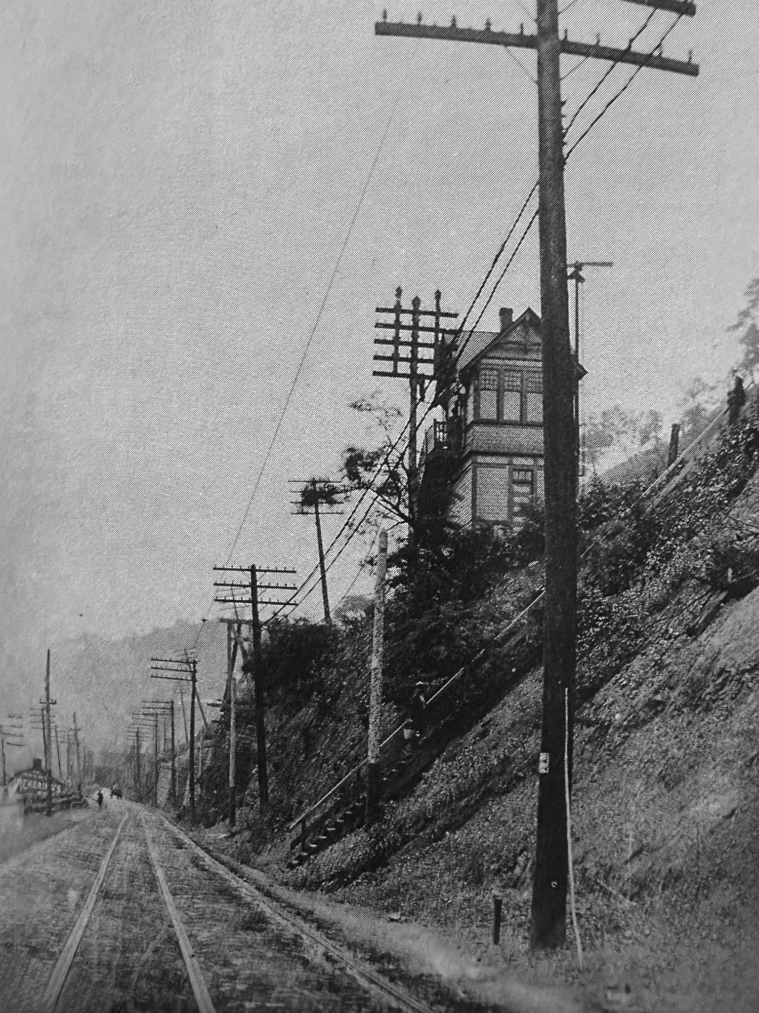 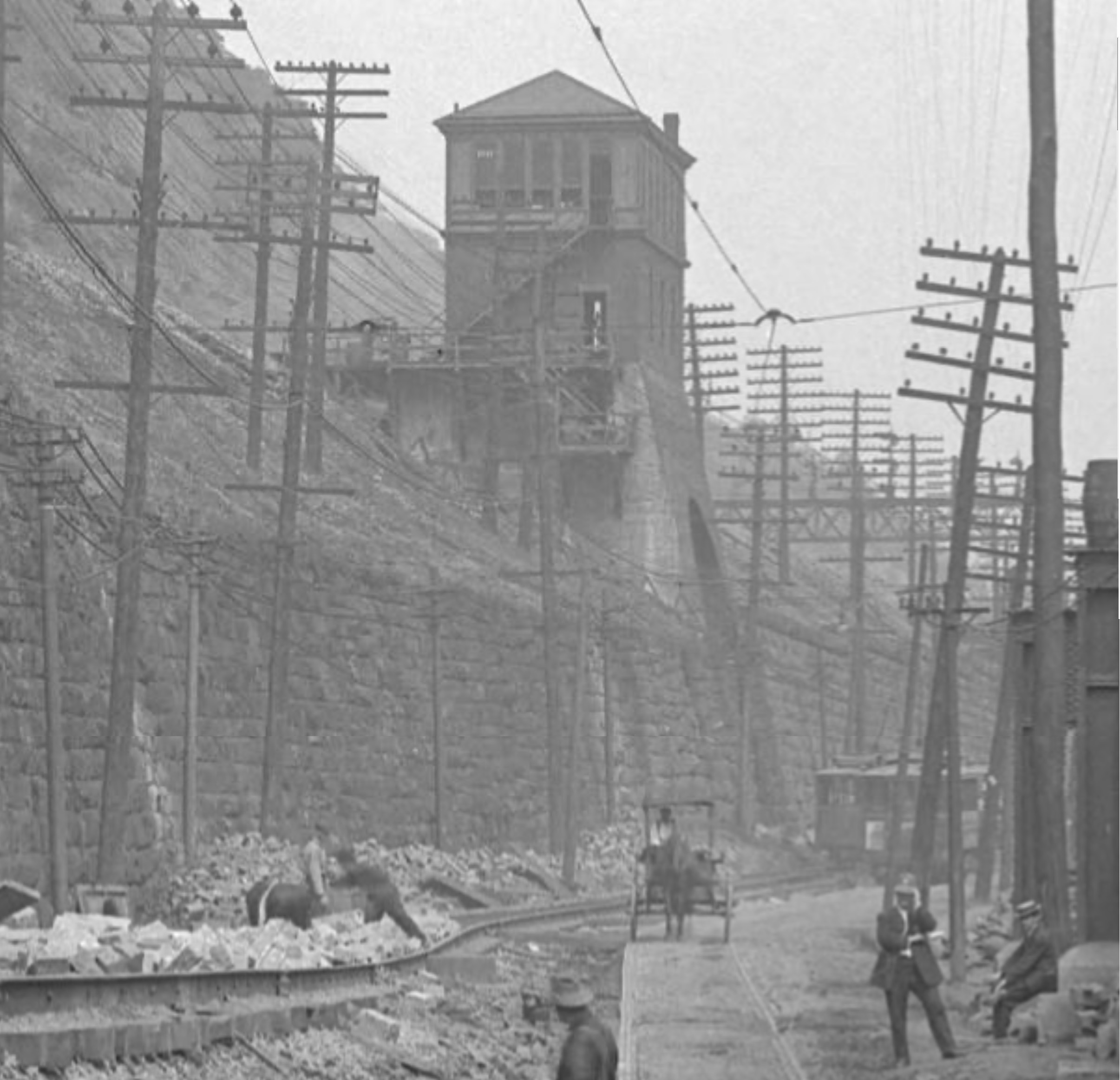 Submit info or inquiry - share some facts or ask a question.
Page created: 17-Aug-2004
|
||
| copyright: © Bruce S. Cridlebaugh 1999-2008 All Rights Reserved | |||